This sublime singletrack gradually ascends the Greenhorn Mountains above the 7,000 ft level in Sequoia National Monument. It is an excellent way to climb to Sand Flat and Frog Meadow from the North.
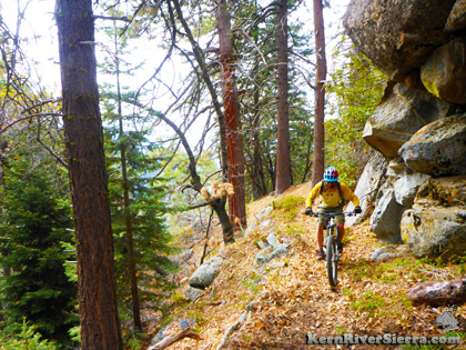
Enroute to Frog Meadow.
|

THE STATS
- Miles: 4.1 miles one way
- Effort: 800 feet in total elevation gain
- Low Elevation: 7000 ft
- Top Elevation: 7750 ft
- Type: Out 'n' Back Ride, or...
- Climb for Tobias Trail, Greenhorn Traverse, etc
- IN: Sequoia National Monument
- WHERE: Greenhorn Mountains
- NEAR: Kernville, Johnsondale, Calif Hot Springs
- BIG XC ride options with nearby Tobias, Frog Meadow (Deer Creek), Powderhorn Trail (Starvation Creek), Bull Run Pass, Portuguese Pass Trails, etc.
- Map: Kern River Sierra Outdoor Recreation Map, 6th ed
|
UPDATE Jan 5, 2021: The trail is clear! The lower section's tread is a bit loose and soft in a few places, but the upper section is great. This trail had a lot more use this fall, and is getting really good. |
On Pup Meadow Trail
In a lonesome part of the Greenhorn Mountains and Sequoia National Monument, Pup Meadow Trail links the Packsaddle Sequoia Grove area with Sand Flat on the Greenhorn Crest north of Baker Point. While this historic trail is one of the original routes accross the Western Divide, it's well-constructed trailbed and modern grade is ideal for pedalling a mountain bike.
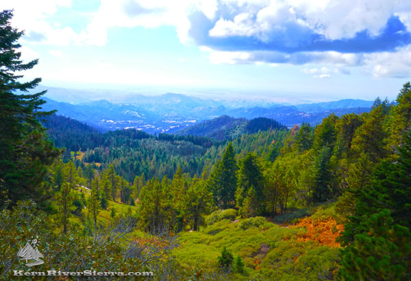 |
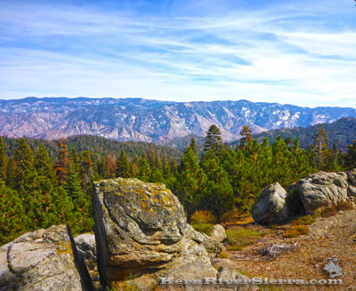
| Looking west from the trail; Pup Meadow is middle left. Lions Ridge is in the middle. California Hot Springs is beyond. |
In just 4 miles, the scenery alternates from western facing vistas of mountains and meadows to a dense lush forest of pine and fir. On the southern end, the trail crosses the ridge where a grand panorama of the Kern Plateau suddenly pops into view near Sand Flat.
The Details
Now that Pup Meadow Trail has been cleared, it will most likely become the main way to climb to Tobias Trail and be used as an important link in a huge trail network. It also generally connects to Speas Ridge Trail and Flynn Canyon Trail, which still need brushing and trailwork to reopen for biking.
 |
 |
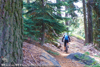
Pedalling the upper section of Pup
Meadow Trail; on the way to Sand Flat, Frog Meadow, and on to the Tobias Trail. |
The micro-climate here attracts far more moisture than most of the area! It can easily be 30 degrees cooler than Kernville. |
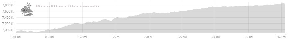
Ascending in the elevation (775 feet in 4.1 miles) from north to south, the trail is divided into 2 sections by the Lion Ridge forest road, 23S73. At 1.5 miles in length, the lower section has a few steeper grades and is a little more challenging to climb. It starts on a rough dirt road just above a large grove of Sequoias. After crossing Lion Ridge (which also has a trail descending toward California Hot Springs), the upper section is 2.5 miles and has a very enjoyable grade for biking. It crests in an area known as Sand Flat, not far from Frog Meadow, Tobias Peak Lookout, and the top of both Tobias and Deer Creek Trails.
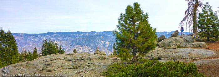 |
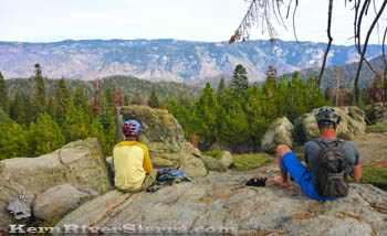
| Near the high point of Pup Meadow Trail and Sand Flat. Views looking east to the Kern Plateau and the Cannell Trail. Salmon Creek Falls and Rincon Trail are straight ahead. |
Note: This trail also used to be called Packsaddle Trail, and is described as such in the Jenkins book Exploring the Southern Sierra: West Side. In an older mountain bike guide book, it was called Frog Meadow Trail. A faint trail ascending the ridge was the upper section of Speas Ridge Trail, which is presently out of use.
Elevation Profile
Ride Options
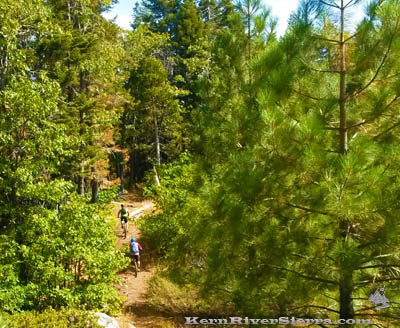 |
| On the lower section of Pup Meadow trail. |
1. OUT 'N' BACK RIDES (with some smaller loop options).
The trail itself provides an 8.2 mile round trip ride with less than 1,000 feet of climbing. This makes for a wonderful and scenic ride, but it's also quite easy to add more mileage with the adjoining dirt roads and also save some driving time.
One starting point is Speas Ridge near Speas Meadow off the paved Sugarloaf Road (23S16). This is a 13 mile round trip ride to the Sand Flat area. Pedalling beyond to Frog Meadow is another 1.5 miles each way.
Ride dirt road 23S73, passing spurs to Speas Dirty Camp and Harris Lookout. After a steep climb, veer right onto road 23S28. At 2.3 miles from from the start (1 mile from the last split), turn left onto the unmarked lower Pup Meadow Trail at a high point.
For a faster shuttle, another access point is off Parker Pass Drive at Double Bunk Meadow (Rd 23S15). Here some 4x4 road/trails lead to the Powderhorn Meadow trail near an old log cabin. This provides some bonus singletrack and passes near another Sequoia Grove. From here, it is about 8 miles to the top of Pup Meadow Trail with over 2,000 feet of climbing and at least 700 feet of descending.
There are some loop options here as well, such as using the Powderhorn/Starvation Creek Trail and Road. It's a fairly confusing area as both road and trail designations and conditions have changed recently. Certainly take the newest Kern River Sierra topo map for this option.
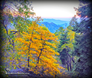 |
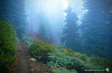
| Trailside sights in the Fall. |
2. PUP MEADOW / TOBIAS TRAIL COMBO
While the other main option is to climb Portuguese Pass Trail or Road (part of which is still recovering from a large forest fire), both the shuttle and the climb are easier using Pup Meadow Trail. Start at either Speas Ridge or Double Bunk Meadow (more pedalling but shorter shuttle), or on any of the surrounding dirt roads. Climb Pup Meadow Trail and merge left onto the dirt road at the end. Stay high on the main road (24S50)until reaching Frog Meadow and the start of Tobias Trail. From Speas Ridge at 23S16, its a 17 mile ride to Fairview Bridge, while its 18 miles from Double Bunk Meadow on M50/Parker Pass Road. Both options have over 2,000 feet of climbing with 5,000 feet of descent.
The entire ride is sometimes looped by climbing the scenic Mill Creek Road 22S10 out of Johnsondale.
NOTE: Tobias Creek Trail is still a big adventure ride and very remote. The trail is very narrow, often steep and challenging, and conditions change rapidly. It is almost always ridable, but usually it's still quite bushy.
 |
| Hanging out at the top. |
3. THE GREENHORN TRAVERSE
An epic ride! From north to south, ride from Double Bunk Meadow to Pup Meadow Trail, along the Tobias Crest at 8,000 ft to Bull Run Pass, to North Portugese Pass Trail to Portuguese Pass Trail to Unal Trail to Just Outstanding Trail. For an even longer ride, continue on Rancheria Road to Badger Gap Trail and Kern Canyon Trail.
4. BIKEPACKING
Its the Giant Sequoia National Monument, go explore it all! Besides the many obvious trails, some other highlights to check out might include the Tobias Lookout Tower and Baker Point Lookout Trail for amazing views.
5. OTHER RIDE OPTIONS
 |
| Sand Flat, in the Greenhorns. |
Larger loops are possible by connecting Pup Meadow Trail with the Powderhorn/Starvation Creek Trail. Several nearby dirt roads give varying loop options.
On the west side, opposite Tobias Trail, is the Frog Meadow (Deer Creek Trail). While its super fun on a mountain bike, it's a bigger shuttle - or a much bigger ride back up. Same goes for Lion Ridge Trail (which needs brushing and maintenance).
Hopefully both Speas Ridge Trail and Flynn Canyon Trail will be reopened above Johnsondale soon. Both of these will add several more riding options with world class views of the Needles and the High Sierra.
Trailhead Directions
From Kernville:
Drive north on M 99/Sierra Way toward Johnsondale. (The end of Tobias Trail is at the upper Whiskey Flat Parking area near McNally's, about 15 miles north of Kernville. For the Tobias Shuttle, leave a car here.) Continue over the Johnsondale Bridge and pass Johnsondale and Lloyd Meadows Road by keeping left. (M99 is now called M50) Turn left on the paved Sugarloaf Road 23S16 (4 miles past Johnsondale) and take this 5.5 miles to Speas Ridge at the dirt road 23S73.
Another access option is to stay on M50/Parker Pass Road another 2.9 miles to Double Bunk Meadow at 23S15. (This is before reaching 107/Western Divide Hwy and 6.8 miles from Johnsondale.)
From California Hot Springs:
Take M50/Parker Pass road and toward Parker Pass. One access is at Starvation Creek Road 23S64 2.5 miles before reaching Parker Pass. Another access point near Double Bunk Meadow at 23S15 is less than 1/2 mile beyond the Western Divide Hwy (107). The Sugarloaf Road/23S16 access is 3.3 miles past Western Divide Hwy. See above for additional details.
Current Webcam Views
View lookinBaker Point Webcam: Similar view from the Upper Pup Meadow/Sand Flat area looking North and East
Sherman Peak Webcam looking southwest towards the Greenhorn Crest
Western Views (SW From Mule Peak) far below Pup Meadow Trail
Nearby Trails & Activities
|

