One of the most popular trails in the Sierras. Must do this.
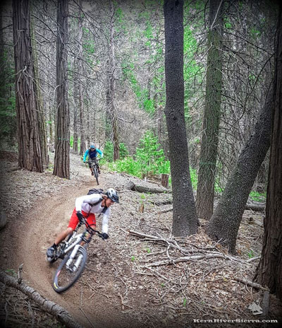
After the famous Manzanita Tunnel, its back-to-back flowy banked turns.
UPDATE: May 15 2025: The trail has seen a lot of love and maintenance lately. Its riding fast, and is in the best condition since the 2021 French Fire!
THE STATS
16 miles (depending on ride - actual trail is about 5 miles)
Motorized Multi-use Singletrack
900 ft up
5,000+ ft down
Shuttle Ride;
Loops are also ridden on the upper section
Carve you way through cedar forest and into an unforgettable manzanita tunnel on this fast flowy trail. The ride is just so outstanding that there's even a beer named after it. And by the time most dusty riders reach the valley floor, they're craving some of that refreshingly relevelant IPA.
Simply outrageous.
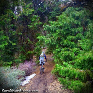
Trail conditions change throughout the year. With any moisture, its completly awesome!
Ride Variations
LOOP OPTIONS: For those who enjoy biking loops, there is a nice 5+ mile ride on the top of Just Outstanding. Ride the top 3 'sections' (road crossings) down and climb back up Rancheria Road. You will cross Rancheria Road on the first road crossing, and then another dirt road that wraps around Cook's Peak. On the third section, the singletrack merges right onto an old logging road and quickly comes to an intersection. At this point, riders usually go left and down JO. However, you can pedal to the right and stay on the old logging road, which meets up with Rancheria Road. Turn right on Rancheria Road and pedal back up to complete the loop.
Adding a few more miles, Unal Trail is a sweet addition for a longer ride or loop.
If you are super gnarly, loop the whole ride by climbing Old State Road.
Mud Hen Trail Alternative:
Melting snow makes Spring hero dirt!
Bikers can also veer off the trail on to Mud Hen Trail and fly down this to Sawmill Road. A loop is possible by riding back up Sawmill Road. Or continue on to Dutch Flat Trail (see below).
SHUTTLE: Usually ridden as a downhill trail, JO is most often shuttled (MRA has shuttle service) from Alta Sierra Ski Resort.
The main JO singletrack is about 5 miles long and drops you half way down the mountain. After a quick-but-steep climb above a creek crossing, the trail ends at Waggy Flat (dirt) Road.
From this point, there are a few possible options of varying difficulty:
1. Old State Road: The original JO ride: When the singletrack ends at a dirt road, turn left and climb Waggy Road for a couple miles to a saddle. Continue down the 4X4 road for a couple miles, and then turn right on Old State Road (graded dirt) and coast down to Wofford Heights.
2. Wagy Ridge Trail:This is a popular version of the ride; turn left and climb Wagy Road to the saddle, then turn right on Wagy Ridge Trail. The challenging trail ends at Sawmill Road, if other options are not taken (a great trail veers off this, but it is on private property and very difficult to find. It is not the motorcycle trail that veers off onto private property as well). An alternative parking area is at Boulder Gulch Campground, just below Sawmill Road.
3. Sawmill Road: Probably the easiest of the options, turn right and descend Waggy Road to Sawmill Road. Go left on Sawmill, and take this all the way down to Hwy 155.
4. Dutch Flat Trail: This is a local classic and one of the best options; JO to Sawmill Road, to Granite Trail (a few options here), up Wall Street Trail and Down Dutch Flat into Keyesville.
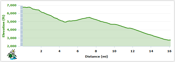
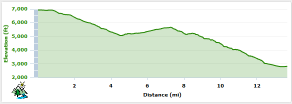
Elevation Profile for Just Outstanding to Old State
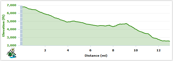
Elevation Profile for Just Outstanding to Dutch Flat
Elevation Profile for Just Outstanding to Waggy Ridge
Trailhead
The trailhead is 2 miles south of Greenhorn Summit on Rancheria Road at the Alta Sierra Ski Resort Parking area. Take Hwy 155 about 7 miles up from Wofford Heights, and turn left at the Greenhorn Summit. Drive to the ski area parking, about 2 miles farther. From the parking lot, ride south along Rancheria Road (25S15) almost a 1/2 mile, and look for the trail on the right.
Video clips from local riders
Video from local rider Jeff Sherman.
The group is riding Just Outstanding Trail to Wagy Ridge Trail:
Scenes from sections on Just Outstanding Trail only:
In case your obsessed, here's another video from BIKE MAGAZINE. They are riding Just Outstanding Trail to Dutch Flat Trail ending in Keyesville.

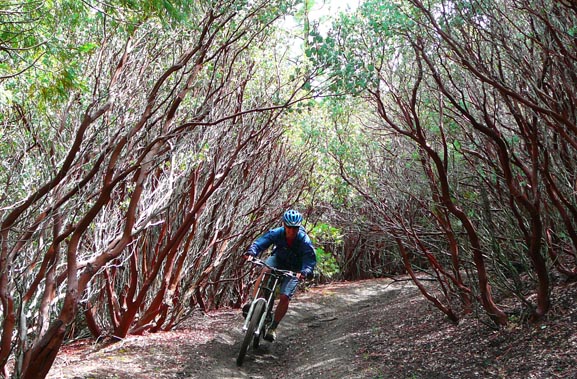 After the famous Manzanita Tunnel, its back-to-back flowy banked turns.