A challenging, fun, flowy Ridge Trail with great views near Just Outstanding Trail and other BLM Trails.
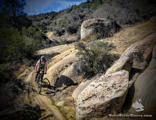
Feeling that tech flow on upper Wagy Ridge.
|

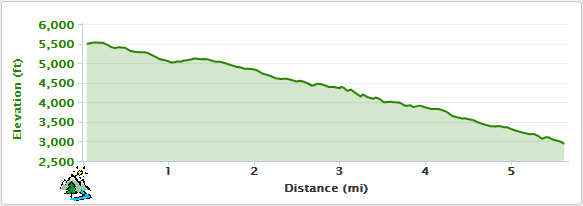
THE STATS
- 5.5 Miles
- 300 feet of climbing
- 3000 feet of drop
- One Way Shuttle Ride
- Loop option w/ Sawmill Rd
- Motorized Multi-Use Trail
- Year-round riding usually
- Top Elevation: 5500 ft
- Lower Elevation: 3200 ft
- Sequoia Nat. Forest & BLM
- Access: Wofford Heights/Alta Sierra area
- Map: Kern River Sierra Map
|
UPDATE: March, 2021: This trail is riding AWESOME right now! A lot of brushing and dirt work has made this even better. The connecting Rocky Gorge Trail had a ton of work and is riding really well also- making a super fun J.O./Wagy/Rocky Gorge/up to Dutch Flat Combo ride.
Take all the mountain bike re-routes, which have transformed this ride with some fun contouring singletrack that avoid the steep sections on the original trail. |
The Ride
 |
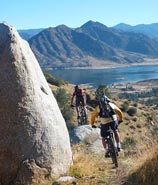
| Upper Wagy Ridge Trail. |
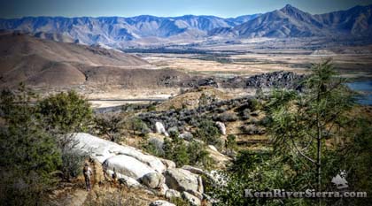
Wagy Ridge Trail has it all: fast singletrack, segments with roller coaster flow (especially on the upper section), tight technical segments, offshoots with fun granite sections, and a couple quick steep climbs with breathtaking panorama views of the lake.
Commencing on USFS land and continuing through BLM property, Wagy Ridge is a multi-use trail that is also ridden by motorcycles. The trail can be biked year-round, except after recent low-elevation snow storms. In the summer it is usually ridden in conjunction with Just Outstanding Trail, while it is accessed from Sawmill Rd in the winter.
The trail connects Wagy Flat Rd to lower Sawmill Road, but many mountain bikers ride the top and then turn off to ride other trails in the area. (See below).
The original route follows the ridge up and down steep hills, and was often rutted out. The trail now has many sustainable improvements, which has added significantly to the preservation, flow, and general enjoyment of the trail. For one's first ride, it really helps to follow someone who knows the trail and all the new re-routes. With some of the sudden turns and quick gravityless transitions, this trail constantly becomes more fun each time you ride it.
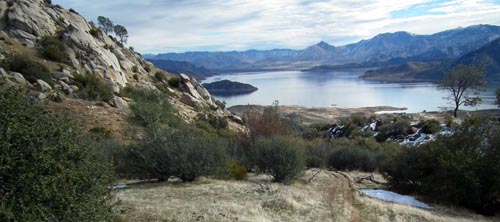 |
| Endless views of granite, water, and mountains along this trail. |
Overall it's downhill, but there are a few short pedally sections. The faster you can ride the trail, the easier and more fun it is!
The lower half of the trail does get ridden, but is not as good as the upper sections.
A local video with great footage of Wagy Ridge Trail (it also has a section of J.O. at first) is here. Another video on the top half of Wagy Ridge below:
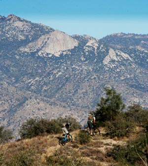 |
Keep your speed up! |
Other Trails in the Area
When Wagy Ridge Trail is combined with Just Outstanding Trail, you get a superb Southern Sierra shuttle ride and a favorite local route.
After the initial downhill section of Wagy Ridge Trail (about 1.2 miles), the singletrack climbs a hill and comes to a trail intersection.
To the right (south), the Rocky Gulch Trail descends 1.5 miles to a gulch and then climbs back out to Sawmill Road after another 1/2 mile+ (there was a lot hike-a-bike involved on the original trail, but there are some large reroutes (easy to miss, on the left side) that are now great for biking). This trail is often used to link the Sawmill Area Trails, Wall Street Trail, and especially Dutch Flat Trail to Keyesville for another Kern River Valley epic covering a lot of varied terrain. This section contains some of the most Sierra Slickrock (granite slabs and features) in the area.
AGTO, is also nearby. It's on private property and is a bike-specific trail (no motos!), so the details of the ride aren't on this website. Find a local to show you - its the best trail around! (Just a note: It is not the motorcycle trail that veers left off of Wagy Ridge just after one of the longer contouring reroutes.)
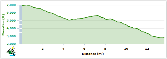
Elevation Profile (from Wagy Ridge Road to Sawmill Road)
Elevation Profile for Just Outstanding through Wagy Ridge Trail
Wagy Ridge/Rocky Gulch Loop and Winter Riding
 |
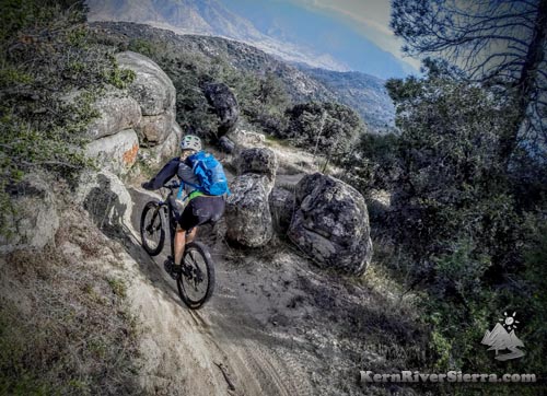
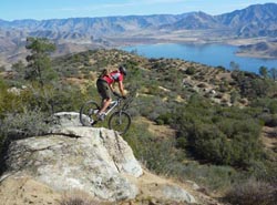
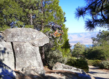
| Riding the natural features. |
Some of the best winter riding in the Kern River area is located here. As the temperature cools off and a few rain storms pass through, the trails just get better and better.
There are also several loop options on these trails off Sawmill Road. Drive up Sawmill road to the USFS land and park in one of the dirt pullouts. For about a 8.5 mile ride that climbs roughly 1500 feet: Ride up Sawmill Road and Wagy Flat Road, to Wagy Ridge Trail. Then turn right on Rocky Gulch Trail, which ends back at Sawmill Road. (Toughen this ride up by replacing the Sawmill Rd section with the other trails on the south side of the road. For example: take Granite Trail up to Wallstreet Trail and then come back down the trail that connects to Borderline.)
Riders also shuttle Sawmill Road and lap either Wagy Ridge, Rocky Gulch and/or Dutch Flat Trail as well.
Trailhead Options
From Just Outstanding: Most of the bike traffic comes off Just Outstanding Trail. After the Just Outstanding singletrack meets the dirt road, turn left and pedal a steady uphill grade for a couple miles. At the saddle (highest point before the road descends), the Wagy Ridge Trail (31E84) ascends the knoll on the right.
In the winter, Wagy Ridge Trail can be looped by using Sawmill Road (2.2 miles south of Wofford Heights), along with Wagy Road and Rocky Gulch Trail.
From Sawmill Road: Wagy Road is about 5 miles up Sawmill Road, on the right. If pedalling Wagy Road, you will pass the Just Outstanding turnoff in about 2 miles, and keep biking another 2+ miles to the Wagy Ridge Trail.
 |
|
| Riding the natural features. How can pedalling be this fun? |
Nearby trails. |
Lower Wagy Ridge Trail: Wagy Ridge Trail has many splintering offshoots in the lower sections of trail. To stay on BLM land keep right (after passing Rocky Gulch Trail), and the trail will meet with Sawmill Road about 5.5 miles down.
If taking Rocky Gulch Trail: The trail is unsigned and meets with Sawmill Road about 1/2 mile below the Wagy Road/Sawmill intersection (see above for discussion).
 |
Getting a bit psycho on the upper wagy jeep route. (yes, this is a real photo, and he has an xc helmet!)
|
|

