Both technical and flowy, this trail is studded with Sierra Slickrock.
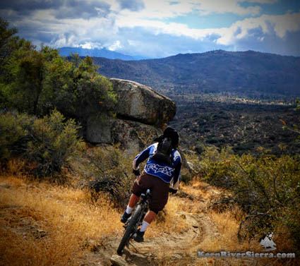 Making winter slalom turns on Rocky Gulch Trail. Making winter slalom turns on Rocky Gulch Trail.
|

THE STATS
- 2.5 Miles
- 240 feet of climbing
- 900 feet of drop
- Usually ridden one-way
- Its best to ride down from Wagy Ridge Tr (1.2 miles) to the trail and end on Sawmill Rd
- Loop option w/ Sawmill Rd
- Motorized Multi-Use Trail
- Top Elevation: 5100 ft
- Lower Elevation: 4400 ft
- BLM Land
- Access: Wofford Heights/Alta Sierra area
- Map: Kern River Sierra Outdoor Recreation Map, 6th ed
|
| UPDATE: March, 2021: Trail has been manicured, maintained and is riding awesome!!! No brush at all! On the climb back out, look for the fainter mountain bike trail that bypass the steep hike-a-bike section on the main trail! Its on the left -beyond a large boulder - after crossing the creek and climbing up a short section of steep trail. Everything is 100% bikable now. |
The Ride
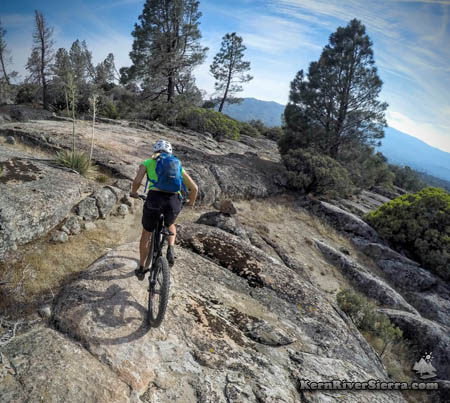 |
| On one of the granite slabs. |
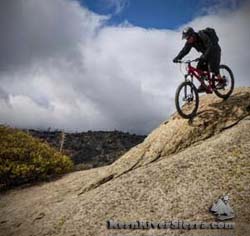
Packed with nonstop action and almost continuous twists and turns, this dirt singletrack is interlaced with numerous rock obstacles and balance-testing granite slabs.
It has a few sections that will remind riders of Gooseberry Mesa or Moab - with a distinct Kern River Valley flavor.
Rocky Gulch Trail is a 2.2 mile trail that continues off Wagy Ridge Trail at about 5100 ft of elevation. It has massively improved this winter (Nov 2015), and is now being integrated into some of the epic rides in the area.
The Details
After riding Wagy Ridge to the first major intersection (about 1.2 miles), turn right at the split for Rocky Gorge Trail (unsigned). The trail continues in the character of upper Wagy Ridge Trail, but is a bit more technical with more rock features.
The majority of the trail is downhill, and the pace really starts cranking as you approach Rocky Gulch. However, the gulch is the low point of the trail so about 3/4+ miles of climbing ensues. Previously, there were some tough sections of hike-a-bike, but there are some great new re-routes that massively improve the quality of the ride out. Because they are new, they are not very obvious. Immediately after crossing Rocky Gulch, the trail steeply climbs a little ways (about 300 hundred feet beyond the gulch).
 |
| Some Sierra Slickrock. |
There is a band of rocks to the left, and a new climb trail starts just beyond. Not too far after the trail reemerges with the original Rocky Gulch Trail, another re-route veers off left just before a righthand turn.
The trail ends at Sawmill Road. Turning left leads to the "Granite Trail," which crosses French Gulch and climbs up to Wall Street Trail and eventually to Dutch Flat Trail. Going right on Sawmill Rd leads to 2 other trails that connect to Wall Street Trail and Keyesville (one veers of Borderline 4x4 Rd), and to Wagy Flat Rd in 1/2 mile. Note that these trails are unsigned, except for Dutch Flat.
When to Ride
If it's not too hot:
Add this trail to the Just Outstanding to Dutch Flat Ride for a big day on the bike.
In the Fall/Winter/Spring:
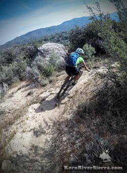 |
| Plenty of twists and turns here. |
Some of the best "off season" riding in the Kern River area is located here. As the temperature cools off and a few rain storms pass through, the trails just get better and better.
There are some good loop options on these trails near Sawmill Road. Drive up Sawmill road to the USFS land and park in one of the dirt pullouts.
Climb Sawmill Rd to Wagy Road to Wagy Ridge Trail, and finish with Rocky Gulch Trail for a 8.5 mile ride.
To add more miles, ride some of the trails on the south side of Sawmill Road. (One option is to take "Granite Trail" up to the ridge/"Wallstreet Trail" and then come back down the trail that connects to Borderline. Or, just keep going all the way into Keyesville via Dutch Flat Trail)
Riders also shuttle Sawmill Road and lap either Wagy Ridge, Rocky Gulch and/or Dutch Flat Trail as well.
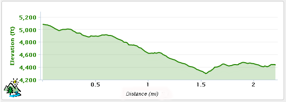
Elevation Profile (From Wagy Ridge to Sawmill Road)
Trailhead
 |
| Love that traction. |
Ride from either Just Outstanding or Wagy Ridge, (click for directions to each).
To loop from Sawmill Road:
Drive to the west side of Lake Isabella. From Kernville, take Burlando Road 6+ miles to Sawmill Road and turn right. This is about 2 miles past Wofford Heights. From Lake Isabella, take Hwy 155 and turn left on Sawmill Road. Once at Sawmill Road, continue up for about 3.8 miles and park in a turnout. (The dirt road to the left leads to the unsigned "granite Trail," which is a good place to start.)
Nearby Activities
|

