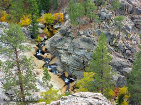
Looking at the teacups from just above Salmon Creek Falls.
The Salmon Creek trail network connects Cannell and Deadwood Trails to Horse Meadow, Big Meadow, and the impressive Salmon Creek Falls. There are a mix of trails and various ways to connect them. The character of your bike ride simply depends on your imagination.
Warning! Some sections of the trail get very sandy in the summer, especially with horse use. The worst section is on the Salmon Creek Trail near Big Meadow.
Primary ride suggestions would include a loop with Cannell, Deadwood, and part of Salmon Creek Trail. Another loop could incorporation Salmon Creek Trail with the lower Deadwood Trail and the Fisherman's Trail. The section of Salmon Creek Trail that extends to the top of the waterfall can be ridden as a demanding out 'n' back, but there are many more difficult and steep sections of riding. Some areas are brushy. The views are dramatic as Salmon Creek precipitously tumbles over the edge of the Kern Plateau. However, unless you have good rock climbing skills, you wont be able to see the actual falls.
The Trails
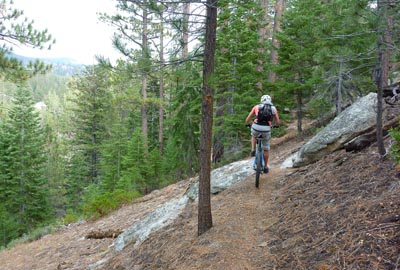
Pedalling back up Salmon Creek Trail.
Cannell Trail connects Deadwood Trail to Big Meadow/Salmon Creek Trail, by way of a steep and rocky route. Although difficult, this is sometimes climbed in order to descend Deadwood Trail.
Deadwood Trail drops steeply from Cannell Trail to Horse Meadow Campground. The top section is non-motorized ripping fast rooty and rocky singletrack. The lower section below Cherry Hill road, is one of the best short sections of trail anywhere. Parallelling the carved out teacups and mini waterfalls of Deadwood Creek, the trail drops over granite ledges on the edge of the water.
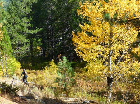
Salmon Creek Trail has many segments starting at Big Meadow, weaving over to Horse Meadow, and then on to Salmon Creek Falls. The higher portions of trail make for easier riding, although there is horse traffic. Depending on the weather and season, this may affect the trail conditions. Overall, these trails are fairly low-use, and can be somewhat faint at times.
Fisherman Trail parallels the creek on whichever side Salmon Creek Trail is not on, and covers a lot of fun featured granite terrain.
Near the top of Salmon Creek Falls, on an old trail.
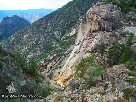
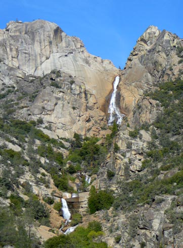
Salmon Creek Falls as seen from far
below; an area near Rincon Trail.
Below is a video filmed on upper and lower Fisherman Trail and Salmon Creek Falls Trail, before it was brushed: (Warning - this isnt a normal bike trail, and has plenty of hiking)
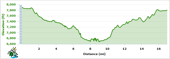
Elevation Profile
This profile is from a partial loop / partial out 'n' back ride that started at Big Meadow, took Salmon Creek Tr to the Fishermans Tr, then rode back to Salmon Creek Trail down to the falls and back, then returned on dirt road 23S08 and back to Salmon Creek Trail (you'll need a map for this one):
Trailhead
For Big Meadow Trailhead: From Kernville, drive north about 19 miles on Mtn 99, and turn right on Sherman Pass Road, 22S05. Drive up this and turn right on paved Cherry Hill Road, 22S12, and continue for about 12 miles to Big Meadow. There is a dirt parking area on left, and the signed Salmon Creek Trail is on the right.
For Horse Meadow Campground Trailhead: Follow the same directions above, except turn right on Horse Meadow Road 3 miles before Big Meadow. Descend just over a mile to the campground area, and park below the campground off a righthand turn. There is a restroom and a trail sign, although the trail is fairly faint/lower use in this area.
Dont Get Lost!
The trails are depicted on the Kern River Sierra adventure map, 6th edition.