A quick rowdy downhill that drops off the north side of Sherman Pass
 |

THE STATS
- Miles: 1.8; 2.1 back to Sherman Pass Rd
- Tread: Downhill Singletrack
- Trail: Motorized Multi-Use
- Top Elevation: 9200 ft
- Low Elevation: 8200 ft
- Vertical: 1000 ft
- How: Loop with road, or shuttle
- Land: Sequoia National Forest
- Where: Kern Plateau, Sherman Pass Rd
- Trailhead Access: Sherman Pass Overlook
- Near: Kernville, Kennedy Meadows
- Options: Connects to several other trails
- Note: Seasonal Closure due to snow.
- Map: Kern River Sierra Outdoor Recreation Map, 6th ed.
|
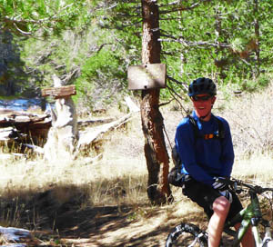
Sherman Pass Overlook
The Sherman Pass Overlook area is such a playground for mountain bikes! Not only is this the trailhead for IMBA Epic Cannell Trail, but also the non-motorized Sherman Peak Trail and the fun downhill on Sherman Pass Trail.
 |
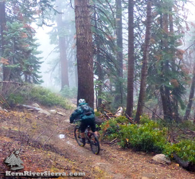
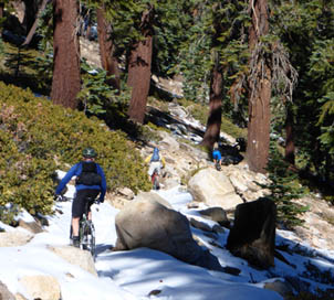
| Feeling some speed on Sherman Pass Trail. |
This singletrack is just a hint of what else is offered on the Kern Plateua, with hundreds of miles of connecting trails.
Dont miss the views of Mt Whitney and Olancha Peak to the north at the Sherman Pass Overlook. Also in view are several hikes and rock climbing areas.
On the Trail
Sherman Pass Trail drops off the northside of the Overlook (the opposite side of Cannell Trail) on the east side of the pavement. Its about 2 miles of both technical rowdy-at-times tread and smooth flowy singletrack over a 1000 foot descent. On the way down, it crosses a USFS forest road; keep going! Enjoy this fast and fun as it darts down through a pine and fir forest at 9,000 feet in elevation.
Ride Options
The trail ends at Trout Creek Trail. Turn left to climb quickly back to Sherman Pass Rd and loop back up to the trailhead.
OR continue on to the upper Trout Creek Trail network. This connects to the High Meadows Loop and the Cedar Canyon Ride.
 |
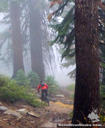
| Be prepared for any weather at this elevation! Riders in a thunderstorm. |
One could also turn right on Trout Creek Trail and explore the Boone Meadow area. [Boone Mdw Trail is also makes a really fun downhill.] An epic loop ride is to combine this with Sirretta Trail and Cannell Trail, but expect a remote 5,000 foot adventure with hike-a-biking.
The entire Kern Plateua offers endless oppportunity for bikepacking as well!
There are so many options, but combining with the High Meadows Loop or some of the shorter loops and nearby trails is the most practical.
Add on a Sherman Peak ride, or loop the upper sections of Cannell Trail out to mosquito meadow.
All of these trails are depicted on the Kern River Sierra Map, along with the nearby rock climbing and hikes.
 |
 |
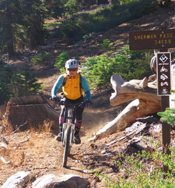
| At the Trout Creek Trail intersection. |
Snow at the top of the ride, at 9200 ft. |
Directions & Trailhead
Sherman Pass / Cannell Trailhead. From Kernville, the trailhead is 1+ hour away. Drive up Mtn 99, then turn right before the Johnsondale Bridge onto Sherman Pass Drive and go up to the parking area at the top.
Or drive from Kennedy Meadows on Sherman Pass Road.
Other Nearby Activities
- Go bikepacking for days
- Bike Sherman Peak Trail, Cannell Trail, High Meadows Loop, Cedar Canyon Trails
-
Hike nearby Bass Peak or Sherman Peak
- Hike Sirretta Peak, Durrwood Creek Canyon & beyond,
Lookout Mountain & Schaeffer Mountain, or Loop Lookout Mtn, Schaeffer Ridge, Stony Mdw, Smith Mountain, Granite Knob, Cannell Peak
- Hike Domelands - Manter Meadow
- Hike or Climb Taylor Dome & Church Dome
- Rock Climb Spirit Rock, Ghost Rock, Kenu Wall, Sherman Pass Crags, Boy Scout Rock
- Fly fish the South Fork of the Kern
- Raft or Kayak The Kern
- Kiteboard Lake Isabella
- Ski in the winter!
|