A nature-immersed singletrack trail off the beaten path.
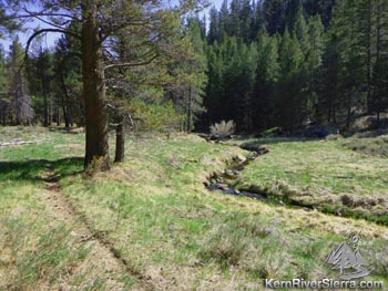
Fish Creek Trail weaves its way through this idyllic setting. |

THE STATS
- Miles: 7.8 Miles of trail
- Total: 17.5 Mi loop (w/ Rd)
- Tr: Nonmotorized Multi-Use
- Effort: 150 ft of climbing
- Thrill: 1250 ft of drop
- Total: 1500 ft cumulative gain/loss on Loop
- Optional Shuttle Ride
- Note: Numerous Creek Xings
- Top Elevation: 8900 ft
- Lower Elevation: 7800 ft
- Best: Summer, Fall
- Land: Sequoia Nat Forest
- Where: Kern Plateau, Black Rock Station, Kennedy Meadows
- Map: Kern River Sierra Map
|
| May 2018: All logs & brush have been cleared, and the trail is 100% ridable except for 2 creek crossings. One has an easy log crossing, but the other is now a small beaver pond (take shoes off). All other crossing are ridable through shallow water. The trail surface is filled with small bumps from last year's horse tracks and some cows in the lower sections. |
The Ride
 |
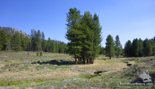
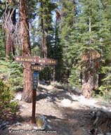
On the upper section of Smith Mdw Trail.
|
While most the trails in this area are open to motorcycles, this ride only sees a few hikers, bikers, and horsemen every year. With the low-use and excellent scenery, it almost feels like a Wilderness trail. Following Fish Creek through meadows, trees, and a bouldery canyon, the ride abounds with wildlife. In one ride, we've encountered 2 bears, coyotes, deer, a beaver, and numerous waterfowl. In the summer, the meadows can be filled with gorgeous handlebar-high Monkshood and other flowers.
The ride is actually made up of one continuous trail with three different names. Commencing above 8,000 feet in elevation, the Smith Mdw Trail is the first main section of trail. It has most of the downhill action and a few more challenging sections along the upper creek. After crossing Smith Meadow, the trail becomes "Fish Creek Trail" and weaves its way through forests and open meadows. As the trail completely flattens out, it become "Pack Station Trail" with more evidence of local horse and cow use.
 |
 |
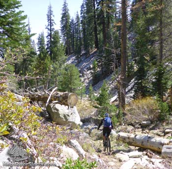
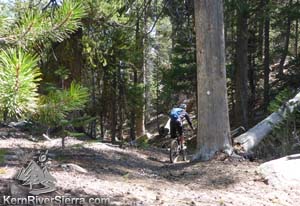
Pedalling through Rocky Canyon.
|
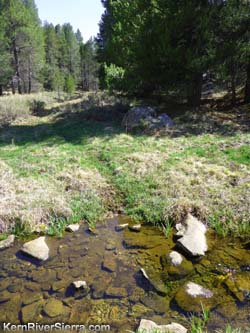
One of the many creek crossings. |
There are numerous creek crossings - too many to count (20?), especially in the lower half of the trail. On a low-water year or later in the summer, these crossing are all ridable except for one or two.
While the first couple miles have some super fun downhill sections, most of the ride is much flatter with consistently easy pedalling.
The Details
 |
 |
 |
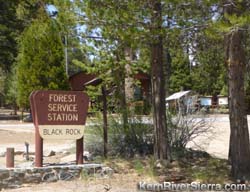
Blackrock Station. The described ride starts here.
|
Look for this sign from Blackrock Road. |
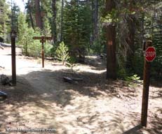
Dont miss this intersection onto Smith Mdw Trail (Fish Creek). |
To loop the trail, park at Blackrock Forest Service Station. Start riding north up the paved Blackrock road, almost to the end at the Wilderness boundary.
 |
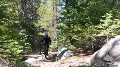
Most of the riding excitement comes in the first two miles.
|
At 7.8 miles, spot the signed "Blackrock Mtn Trail" on the right of the road. Take this fun moto trail, and soon you will come to an important intersection with a stop sign. Go Right here! There is no trail sign (only a no-motorcycle sign), but this is Smith Meadow Trail.
The next section of trail contains the majority of downhill for the entire ride; enjoy! You are now riding down the Fish Creek drainage. A few boulder gardens spice up the otherwise easy trail.
When the trail comes to a meadow, it's easy to lose it. The trail veers over to the right in the trees. If you can't find it, follow the meadow down and veer slightly right toward the end.
 |
| Beautiful scenery the entire way. |
In about 2.5 miles, the trail crosses the paved road that leads to Granite Knob and the Jackass Creek Trail. Cross it and continue through Smith Meadows. The trail heads to the right and back into the trees.
Soon the trail reaches the Albanita Trail and a dirt road that leads to a private inholding. Head straight across and onto the Albanita Trail. You will parallel a barbed wire fence for about .1 miles. Look for the signed "Fish Creek Trail" off to the left.
In about .6 miles, the trail merges briefly with another private dirt road and then continues along the fence of a cow camp.
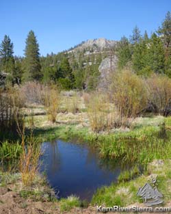 |
| Beaver pond blocking the trail. |
When the trail comes up to the meandering creek into a gorgeous meadow, go left and cross the creek (don't follow the cow trail continuing on the right side of the creek). (This is just over 4 miles from the start of the trail at the pavement.) A sign on the shaded tree depicts the way. Continue up the little hill, and on to some fun singletrack.
After passing the trail sign, now stating "Pack Station Trail," the trail has a couple slightly deeper creek crossings. One is a marshy area created by beavers that might require taking your shoes off.
After about 7 miles of trail, you'll spot an old sign on a slight hill. There is a faint trail that ascends to Sherman Pass Road, and avoids the final sandier section of trail. Otherwise, the trail continues toward private property (the old Kennedy Meadows Pack Station), and abruptly turns uphill to reach Sherman Pass Road.
Once at Sherman Pass Rd, turn right and ride back up to Blackrock Station. Ride complete!
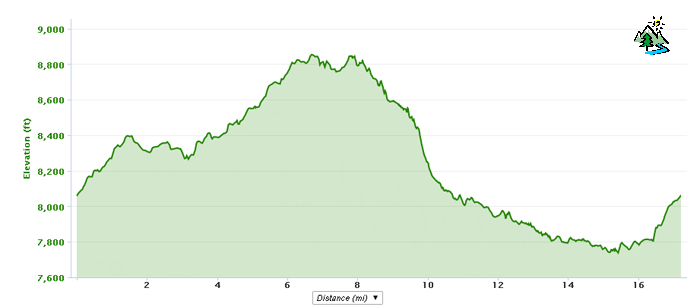
Elevation Profile
Other Rides in the Area
Check out the easy Beach Ridge Trail or Jackass Loops.
Directions to Trailhead
From Kernville: Take Mtn 99 north 19 miles to Sherman Pass Road and turn right. Take this about 33 miles and turn left on Blackrock Road. Just ahead, park at the Blackrock Station on the right.
From Johnsondale: Drive east to the Kern River and turn right on Sherman Pass Road. Take this about 33 miles and turn left on Blackrock Road. Just ahead, park at the Blackrock Station on the right.
From Kennedy Meadows: Drive over the South Fork of the Kern River on Sherman Pass Road. After about 12 miles, turn right on Blackrock Road. Just ahead, park at the Blackrock Station on the right.
Nearby Activities
- Fly Fish the South Fork of the Kern or Fish Creek
- Go BikePacking
- Bike High Meadows Loop, Sherman Peak, Cannell Trail, Cedar Canyon, Beach Ridge Trail, Jackass
- Rock Climb Spirit Rock, Ghost Rock, Trout Creek Rocks, Granite Knob, Jackass Dome...
- Hike Granite Knob, Smith Mountain, Durrwood Creek, Lookout & Shcaeffer Mountains, Sherman Peak...
- Hike Domelands - Manter Meadow
- Hike or ClimbTaylor Dome & Church Dome & Rockhouse Peak
- Raft, Kayak, or SUP the Kern River
- Dirt Bike 100's of miles of trail
- Backpack Domelands or Golden Trout Wilderness
|

