A short easy non-motorized singletrack near Blackrock Station.
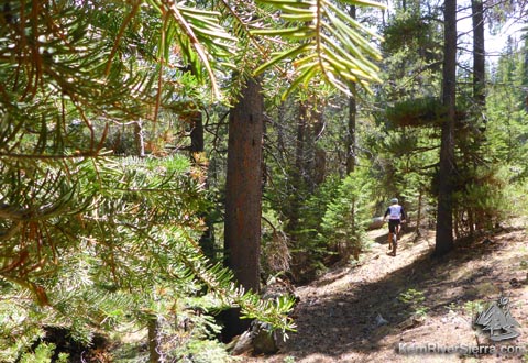
Biking along the non-motorized Beach Ridge Trail. |

THE STATS
- 5.5 Miles.
- 550 feet Gain/Loss
- Singletrack w/ forest road
- Non-Motorized Trail
- Loop
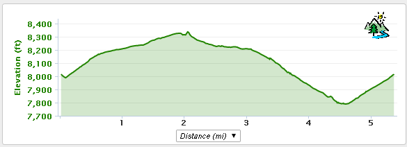
- Elevation Range: 7400-8400 Ft
- Land: Sequoia N.F.
- Access: Kennedy Meadows, Sherman Pass
- When: Summer/Fall
- Map: Kern River Sierra Outdoor Recreation Map, 6th ed
|
UPDATE! May 5, 2017: The trail just opened for the season: almost no use so far, but it has been maintained and all clear. Tons of deer tracks on the trail made it a bit bumpy/choppy. |
The Ride
 |
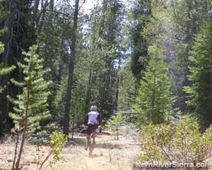
| The start of the singletrack section. |
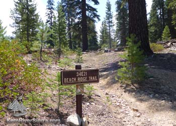
Dont mistake this for the Beach Ridge Trail 34e27, that is right next to this Beach Ridge Trail 34E21. One is motorized, one is not. This ride describes the non-motorized trail, although there are some great sections of biking on the 34E27 too.
Beach Ridge Trail is unique in that it is one of the easiest rides in the region. There are no steep climbs or descents, few obstacles, short, and loopable with an easy road.
Primarily in the forest, the trail parallels a dry creek and passes a meadow.
It can be combined with other rides in the area, such as Fish Creek Trail or Jackass Creek Trail.
The Details
From the Blackrock Station parking and picnic area, ride back down to the intersection with Sherman Pass Road. Make a sharp right onto 21S02, which is a partially paved dirt road, and start climbing.
You will pass the motorized trail and a dirt road as the grade eases.
After almost 2 miles, the road reaches a saddle with some views of Beach Meadows up ahead. Turn left at the dirt road here. Descend about 1/10th of a mile to Beach Ridge Trail 32E21. Turn left here. (the trail continues to the right also, but it's not the greatest bike trail).
 |
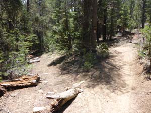 |
Beach Ridge Trail; the the flatter section of the singletrack.
|
The 2 Beach Ridge Trails cross paths: to the right is the motorized section, while the left is non-motorized trail featured in this ride. |
After the short hill, the ride is relatively flat for awhile. The pace and scenery pick up a bit as the ride passes a meadow and then follows the dry creek. Cross the dirt road and then the moto trail. At 3.8 miles, cross over the pavement to continue. At 4.6 miles, the trail reaches pavement again. Turn left on Sherman Pass Road to return to Blackrock Station. (Note: just across the street, is an old connector trail that meets up with the bottom of Fish Creek Trail/Pack Station Trail).
Elevation Profile
Trailhead
From Kernville: Take Mtn 99 north 19 miles to Sherman Pass Road and turn right. Take this about 33 miles and turn left on Blackrock Road. Just ahead, park at the Blackrock Station on the right.
From Johnsondale: Drive east to the Kern River and turn right on Sherman Pass Road. Take this about 33 miles and turn left on Blackrock Road. Just ahead, park at the Blackrock Station on the right.
From Kennedy Meadows: Drive over the South Fork of the Kern River on Sherman Pass Road. After about 12 miles, turn right on Blackrock Road. Just ahead, park at the Blackrock Station on the right.
Nearby Activities
- Fly Fish the local creeks
- Go BikePacking
- Bike High Meadows Loop, Sherman Peak, Cannell Trail, Cedar Canyon, Fish Creek, Jackass
- Rock Climb Spirit Rock, Ghost Rock, Trout Creek Rocks, Granite Knob, Jackass Dome...
- Hike Granite Knob, Smith Mountain, Durrwood Creek, Lookout & Shcaeffer Mountains, Sherman Peak, Bass Peak
- Hike Domelands - Manter Meadow
- Hike or ClimbTaylor Dome & Church Dome & Rockhouse Peak
- Raft, Kayak, or SUP the Kern River
- Dirt Bike 100's of miles of trail
- Backpack Domelands or Golden Trout Wilderness
|

