An outstanding forested trail with some of the biggest Giant Sequoias anywhere!
Good times on this machine-built trail.
NOTE!!!!!!!!!!:
Unfortunately, this trail burned in the Castle Fire and is closed for all of 2021. The Giant Sequoias are hardy and hopefully the forest will quickly recover.
|
THE STATS
- Miles: about 9 roundtrip
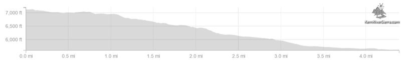
- Top Elevation: 7100 ft
- Lower Elevation: 5600 ft
- Effort: 1500 feet of climbing
- Tread: Machine-built singletrack, Non-motorized Multi-Use Trail
- Type: Out 'n' Back Ride
- Additional mileage with trail continuing on other side of lloyd Mdw Rd.
- Land: Sequoia National Monument
- Access: Western Divide Hwy (near Quaking Aspen Campground by Ponderosa/Camp Nelson) or Lloyd Meadow Road (past Johnsondale)
- Map: Kern River Sierra Outdoor Recreation Map, 6th ed
|
Freeman Creek Trail
 |
| Just another random tree on the edge of the trail. |
A truly unique mountain bike ride, the Freeman Creek Trail weaves its way down the largest unlogged Giant Sequoia grove outside of a national park. If simply riding among these ancient giants in Sequoia National Monument wasn't enough, the trail is also super fun!
The trail descends from near the Western Divide Hwy to Lloyd Meadow area near Golden Trout Wilderness; dropping roughly 1500 feet in elevation. It's not a shuttle ride, so mountain bikers ride this as an out 'n' back from either of the trailheads.
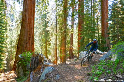
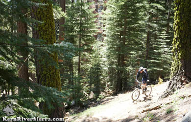
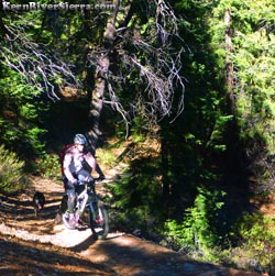
Freeman Creek Trail is a smooth machine-built singletrack (rare in this area), with some fun flowy sections and jumpy features.
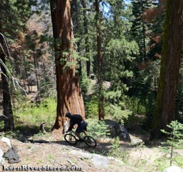
Giant Sequoias
This 1500 acre grove contains 800 trees that are over 10 feet in diameter and a couple that are 20 feet wide. Freeman Grove is also the easternmost grove of sequoias in the US.
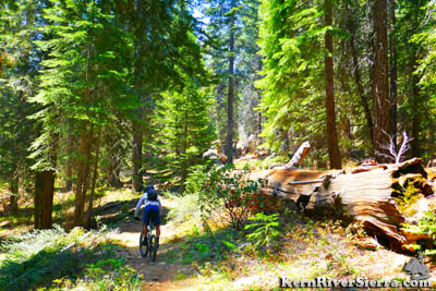 |
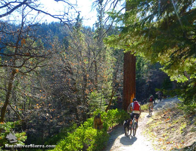
| The Freeman Creek Trail. |
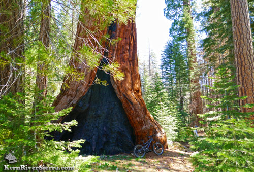
The famous George Bush Tree is a highlight to see; just off the trail with a commemoration sign. An even bigger tree, the Great Goshawk Tree is hidden on the slopes south of the creek. It is the 29th largest tree in the world; 255 feet high with a diameter of 23 feet.
Several other large trees appear just off the trail throughout the ride.
The Ride
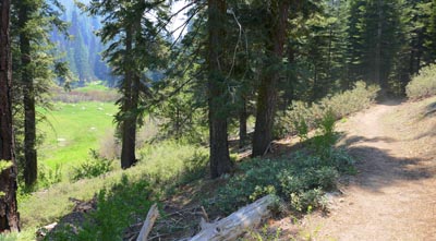
The ride rolls along 1000+ year old sequoias, lush green meadows, idyllic bridges, and a clear flowing creek. Along with the Giant Sequoias, the trail remains in a forest of pine, fir, black oaks, dogwood, and fern for most of the ride.
Part of the trail is fast and steep, while sections of the ride include wide switchbacks. Near the top, it descends a ridge with a quick view of Hermit Spire across the way. The entire lower trail is relatively flat and enjoyable.
 |
George Bush Tree. |
Depending on which trailhead you start at, this out 'n' back ride climbs or descends at first. Roundtrip the ride is about 9 miles with 1550 feet of climbing. There are 2 sustained steep sections trail, less than .25 mile long. The entire ride is climbable, unless the soil becomes too soft.
Like most rides in the southern sierra, the season and recent conditions have a big effect on the trail conditions. Sticks, bark, and needles are often on the trail in the Spring, but the dirt can be excellent. The summer tourist season often brings some guided horse tours, which can impact the trail. Most of the horse use is on the lower 1 mile of trail, enroute to the George Bush Tree.
This is a popular trail on summer weekends, so be aware of hikers and horse riders (No Strava!).
President George H.W. Bush Tree/Freeman Creek Path
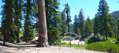
A short wheelchair-accessible dirt path creates a separate loop at the official Freeman Creek Trailhead (see directions below). This is also open to bikes, and makes a good kid friendly loop. Its less than 1/2 miles and has about 40 feet of elevation gain. The parking area sits thousands of feet below the impressive Hermit Rock.
 |
Climbing on an upper stretch of trail. |
Ride Options
Freeman Creek Trail actually continues east across Lloyd Meadow Road, and connects to some other trails in the Lloyd Meadows and upper Forks of the Kern area. These "Lloyd Meadows Trails" can be great early in the season (or late after rain), but often get quite sandy in places.
A fun side hike: Continuing down Freeman Creek, yields some impressive granite teacups and waterfalls after passing the Pyles Boys Camp.
If riding from the bottom: Freeman Creek Trail can be combined with sections of Summit Trail for a super epic long ride.
Another spectacular option is to link it to The Needles Trail to have an amazing day of visual drama.
If riding from the top: For one of the most fun mountain bike days ever, ride Freeman Creek Trail, then shuttle Camp Nelson Trail and/or Bear Creek Trail!
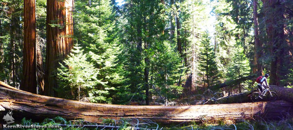 |
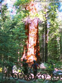
Mountain biking among the Giant Sequoias. |
Elevation Profile
 |
Excellent forest biking. |
Nearby Trails & Activities
Directions
The Upper Trailhead is off North Road, 21S50, which is off the Western Divide Hwy near Quaking Aspen Campground and Ponderosa.
People come from every possible direction for this (and other rides), but once
near the campground, go north on North Road a short distance. A sign on the right marks the Freeman Creek Trail. One can park here, or continue down the dirt road to the gate and official start of the trail.
 |
Early season solitude. |
The Lower Trailhead is off Lloyd Meadows Road, 22S82, which is north of Johnsondale.
Drive about 16 miles north on 22S82. Look for the signs displaying Freeman Creek Trail 32E20 just off both sides of the road. (The trail to the left is the one described above). Most mountain bikers park in a dirt pullout just beyond this on the left.
Another option is to turn left on the dirt road 20S78 and drive up to the George Bush Tree Trailhead.
 |
 |
Freeman Meadows below the trail. |
SEQUOIA SLALOM. |
 |
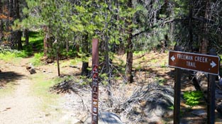 |
Freeman Creek Upper Trailhead. |
Freeman Creek Lower Trailhead. |
|

