Rugged and rough trail traversing the hills above the upper Kern River.
Superb winter riding on the upper stretches of the trail.
Update: March 2021: Sections in the top half have been ridden a ton this winter/spring, and are in good condition. Many of the other sections are a bit bushier. |

THE STATS
- 12+ Miles
- Singletrack
- 1500 feet of climbing.
- 2300 feet of drop.
- Shuttle OR Many loops possible with addtional trails and dirt roads.
- When: Fall,Winter, Spring
- Where: N. Fork Kern River
- Access: Kernville
- Land: Sequoia National Forest
- Note: Currently not an official USFS trail, although it was last century.
- Map: Kern River Sierra Outdoor Recreation Map, 6th ed
|
On the trail
The Old SCE Flume Access Trail, also know as "Opium" or the "Edison Trail," has the potential to be one of the better cross county trails in Southern California. See below for the best ride options.
 |
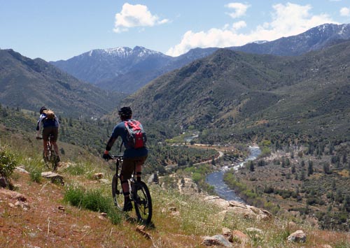
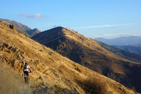
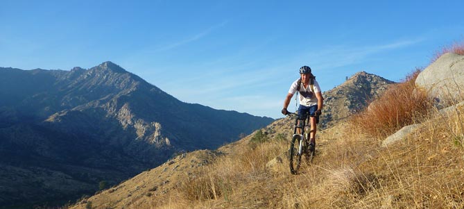
| Riding across Jellowjacket Mtn above Riverkern. |
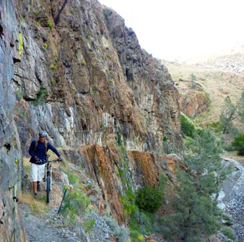
Cutting across the steep slopes of the Kern River canyon, this super scenic trail has many miles of very tight singletrack undulating through a variety of terrain. Sometimes it weaves along golden hills of sierra grass, then dives into small creek drainages, and moves on through a scree-filled mountainous land.
This historic and well-built trail is left-over relic from the hard working men of another time. Local lore states that their grandiose effort was sustained by a substance; opium. Most likely whiskey helped too; but the parallell trail across the river got that name.
In several places along the upper Kern River, one can see the rock-enforced trail carved out of the mountain sides on its way toward the SCE flume pipes above the KR3 Powerhouse.
With the exception of a few hikers, hunters, and bikers, the trail network was out of use for decades and suffered through various fires, rock slides, brush and tree fall over the years.
Sections are still brushy and rough, but the quality of riding is improving rapidly with more use. It is physically and technically demanding, and losing balance in certain sections of trail wouldn't be so fun. Expect a demanding and brushy ride, with some hike-a-biking and quick transitions in the trail.
 |
 |
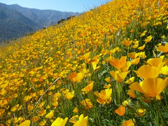
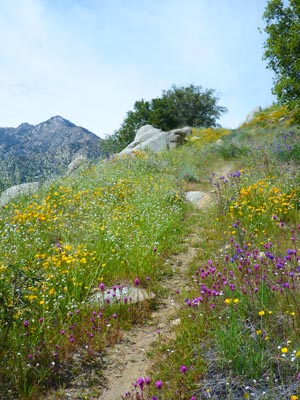
| Spectacular wildflowers covering the slopes. |
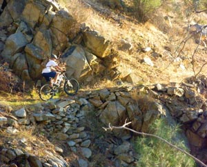
Stacked rocks reinforcing the old trail. |
Certain sections are more fun to ride than others (ask at a local bike shop for the latest conditions), but it is possible to ride from the Rincon Trail area (south of Salmon Creek) to Camp 3 Campground area, and even beyond to a cliffed-out exit at the Forebay Road above Riverkern.
 |
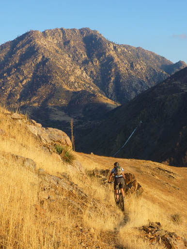
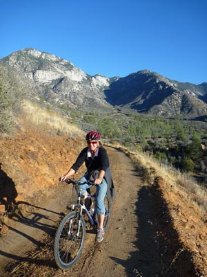
| An evening ride in the Fall, three miles north of Kernville |
Ride options and the various segments of trail
 |
 |
| On the beautiful Camp 3 connector trail. |
On a dirt road just north of Corral Creek. |
The sections of singletrack could be described as follows from north to south: (None of the trails are signed or very obvious).
- Rincon to Goldledge Creek (not completely ridable; still brushy and difficult)
- Goldledge Creek South (a good section, some ride as an out 'n' back from Corral Creek)
- Corral Creek North (narrow but great trail especially riding from north to south)
- Corral Creek South (2 good trail options: upper & lower) (when ridden as a loop, riding counter clockwise maximizes downhill on singletrack with climbing on dirt roads.)
- Thunder Section (ridable with effort, longer section and difficult, some hike-a-bike)
- Yellowjacket Section (needs more trail maintenance, but somewhat ridable with sections of hike-a-bike)
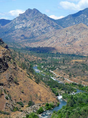 |
| View from the "Thunder" section of Opium Trail. Sock 'em Dog rapid and the Whiskey Flat Trail are seen near the bottom. |
Several SCE access roads are scattered throughout the length of the ride, and take over segments of the trail. For this reason the singletrack is not aways continuous, but will periodically come out onto dirt road. Coupled with its low-use character, this makes the trail really confusing and difficult to find and follow at first. At the same time, it also allows for many different ride options and access points.
Some other trails descend down to the original work camps, which are now campgrounds. The highest use of these is the Camp 3 Trail south of Kernville Dome.
To ride all of Opium, shuttle to the dirt road below the Rincon Trailhead (or the Rincon 4x4 road that ascends from Hwy 99) and ride all the way to Camp 3 or Riverkern. If you don't have someone to show you the trail, expect a some adventure.
The trail below Goldledge Creek is one of the better sections for biking, and has had recent maintenance. It it 100% ridable.
One of the most enjoyable sections of singletrack is north of Corral Creek. Starting near a fabulous viewpoint, it drops below the main dirt road and roughly parallels it for a mile.
South of Corral Creek, there are actually 2 trails. The old original trail stays higher, and traverses for 1.7 miles across the open hillside. It ends at an old flume work landing, where an old road leads down to the next section of trail. A lower trail can be used to loop this section.
By parking at the Corral Creek dirt road, one can combine the loop to the south with a loop to the north (using dirt roads to link the trails). Additional mileage may be added by aslo riding the Goldledge section. The trails are ridable in both direction, although riding both loops counter-clockwise favors climbing the dirt roads and more downhill on the singletrack.
The Thunder Section has awesome views of the Thunder Run section of the river, and some very demanding singletrack. It passes above the New Directions and Kernville Dome rock climbing areas and then dumps you into an old work area with a trail junction. Here, the Camp 3 Trail steeply descends to Hwy 99, while the main trail continues for a couple miles across Yellowjacket Mountain.
With almost 2.5 miles of continuous trail, the Yellowjacket Section has extremely narrow singletrack in places, but is becoming a decent segment of trail. Unfortunately, the trail ends at a very sketchy cliffband near the Riverkern Forebay road. To avoid the cliffs, one option is to take the remains of the old Headquarters Trail down to the campground, about 1 mile before reaching the cliffs.
 |
| Most people skip this cliff section of the trail. |
For power people: the ultimate test of skill and stamina would be to loop Opium Trail with Whiskey Flat Trail.
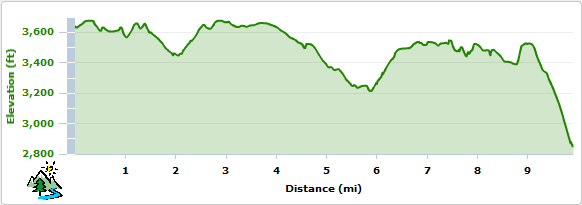
Elevation Profile from Rincon Trail to Camp 3
Trailhead
Corral Creek Access: Drive or bike north of Kernille on Mtn 99. 1 mile past the Hospital Flat Campground, is one possible access. There is a small pullout just past the cattle guard and a 4x4 road ascends to the upper corral trail. The main Corral Creek road is about 1/3 mile farther up the Mtn 99. There is a small pullout there, or a larger staging area up the dirt road on the right.
Northernmost Access: Drive 10 miles north of Kernville on Mtn 99 to (near Ant Canyon). If you want to park and ride from Mtn 99, look for Rincon 4x4 road; there is a small brown sign on the right. You can bike up this road, which will lead to the main SCE aqueduct road that leads to the Opium Trail.
To save the climb, drive past the 4x4 road for another .8 miles on Mtn 99, and turn right on the aqueduct road that is signed "salmon." At the first intersection (with the Rincon 4x4 road), make a ridiculously sharp left turn. At the next junction, turn right and follow this road. You will also pass the a road on the left that leads to the Rincon Trail. You can park in this area or continue to the end, where the unsigned Opium/Old Flume Trail begins. [Note: The first section of trail is the toughest and most overgrown.]
Several of the SCE Flowline Roads between Riverkern and Ant Canyon, also provide access to the trail.
 |
| En route to Kernville. The almost 8,000 ft Baker Point is seen to the left. |
|

